Hardiness Increases Native Plant Success
Deciding what plants will grow on your land takes some thought. While we all know that you cannot grow bananas in Ashland, figuring out what to plant where can be a challenge.
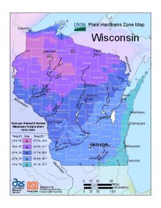
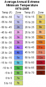
One of the first issues here in Wisconsin is the weather. Summers can be miserably hot while the cold … well, I don’t have to tell you how cold it gets. Still, where you live within the state makes a difference. Plants that grow well for you in Sturgeon Bay may die in the backyard of your brother-in-law who lives in Chippewa Falls.
The difference (aside from your brother-in-law’s black thumb) because the climate between the two properties is their climate zones. Both cities lie along the same latitude but their climate zones are very different.
The USDA plant hardiness zone map provides a convenient tool for determining the plant climate zone for your property. Nurseries and seed producers across the nation use this system to determine how they will guarantee hardiness for the plant stock and seed they sell.
Landowners should consider whether the place they want to plant has a microclimate that could alter their planting decision. Areas sheltered by buildings or south facing slopes might have warmer microclimates than the hardiness map. On the other hand, steep north facing slopes, especially those in dense woodlands, have microclimates cooler and wetter than the surrounding landscape.
Considerations other than hardiness
USDA hardiness zones should never be the sole criteria for selecting plants. Remember to look for plants that thrive with your soils and sunlight conditions. Those factors, just as much as cold tolerance, will determine whether your choices are happy or fail.
Our plants page contains other online tools as well as plant related resources and links to authoritative plant information.